Garmin GPSMAP 67 GPS robust portabil, GNSS cu mai multe benzi, Topo Mapping, imagini din satelit, standard de afișare color

Brand:Garmin

2.7/5

L
4131.63

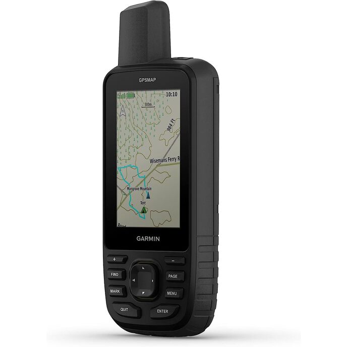
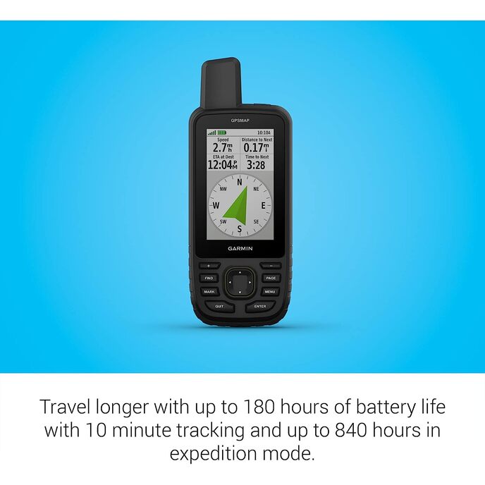
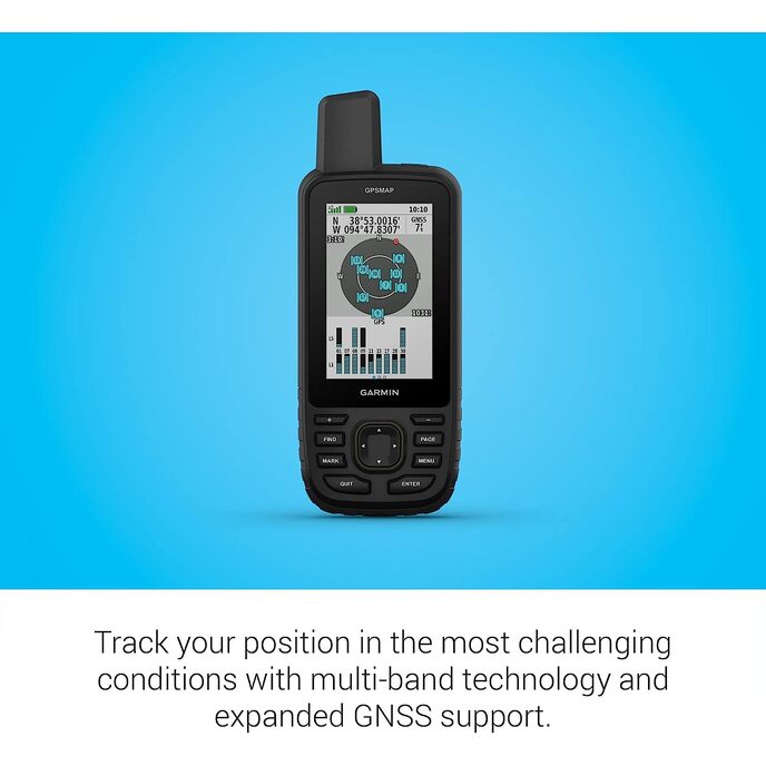
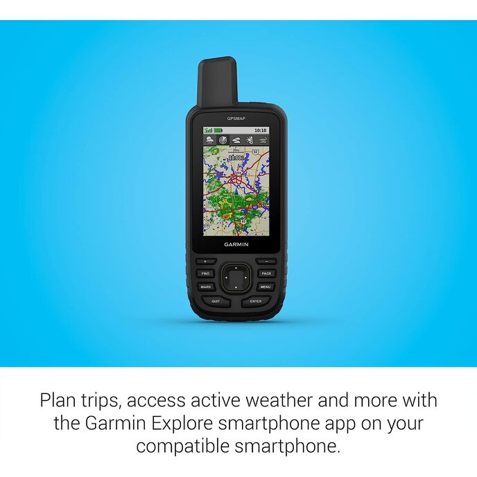
Explorați în aer liber cu dispozitivul portabil GPSMAP® 67. Acest handheld premium, robust, oferă tehnologie multi-bandă și suport GNSS extins pentru o precizie îmbunătățită în țară abruptă, canioane urbane și păduri cu copaci denși. Are un afișaj color de 3” și oferă până la 180 de ore de viață a bateriei în modul standard și până la 840 de ore în modul expediție. Este dotat cu senzori de navigație, cartografiere TopoActive rutabilă și acces la imagini din satelit. Asociați-l cu smartphone-ul dvs. compatibil pentru a accesa vremea activă, Geocaching Live și aplicația Garmin Explore™. Obțineți acces la conținutul de cartografiere Premium cu abonamentul Outdoor Maps+.

Obțineți acces la o mare varietate de conținut de cartografiere premium cu un abonament Outdoor Maps+. Utilizați cu site-ul web sau aplicația Garmin Explore de pe smartphone-ul dvs. compatibil pentru a vă ajuta să planificați călătorii și multe altele. Conectivitatea wireless extinsă acceptă vreme activă pentru prognoze actualizate și radar meteo animat plus Geocaching Live pentru sincronizarea și actualizările mobile atunci când este asociat cu smartphone-ul compatibil. Navigare oriunde cu busolă pe 3 axe și altimetru barometric. Alimentat de o baterie reîncărcabilă internă Li-ion, cu până la 182 de ore de viață a bateriei în modul standard și până la 840 de ore în modul expediție. GNSS extins și tehnologia multi-bandă vă permit să obțineți o precizie sporită în locații dificile, inclusiv în țară abruptă, canioane urbane și păduri cu copaci denși. Afișaj color mare de 3” care poate fi citit la lumina soarelui pentru o vizualizare ușoară.
Batteries 1 Lithium Ion batteries required.
Brand Garmin
Color Black/Green
Connectivity technologies Bluetooth, USB
Customer Reviews 3.7 3.7 out of 5 stars 8 ratings 3.7 out of 5 stars
Human Interface Input Buttons
Item Dimensions LxWxH 2.5 x 6.4 x 1.4 inches
Item model number AA4624
Item Weight 8.1 ounces
Manufacturer Garmin
Map Type North America
Model Name Garmin GPSMAP 67 series
Mounting Type Found in image, Wrist Mount
Other display features Wireless
Product Dimensions 2.5 x 6.4 x 1.4 inches
Screen Size 3 Inches
Sport Camping & Hiking, Outdoor Lifestyle
Whats in the box GPSMAP 67 or GPSMAP 67i handheld device, type-A to type-C USB cable, carabiner clip, documentation
Wireless communication technologies Bluetooth

2.7

7 Review
5 Star
48
4 Star
26
3 Star
0
2 Star
0
1 Star
25

Scrie o recenzie

E-mailul dvs. nu va fi publicat. Toate câmpurile obligatorii sunt marcate cu*

Scritto da: MARK
I'm able receive Satellite Reception from Four Different Satellite Systems
I've had many Garmin GPS receivers (most recently, 66s, Oregon 600, Etrex 32x). Having recently purchased a Garmin SportWatch, I wanted the same degree of accuracy I was seeing with the multi-band Epix. Not too many handhelds to choose from, I thought about waiting for a possible update to the Oregon (800?) but decided to go with the GPSMap 67. My only reservations was it was a "big" device and using the menu interface was slower compared to the touchscreen on the Oregon. Positives... No issues uploading my custom map images (IMG) to the SD card using the legacy MapInstall app. I also manually moved the default TopoActive maps that come installed on the device's internal memory to the SD card. Unit has a robust download of (free) satellite images over your WIFI through Outlook+. The device boots fast and almost instantly locks on to the location. My device is seeing the following satellite systems: GPS (USA), Glonass (Russian), Galileo (European) and Beidou (Chinese) on multi-bands of reception. Initially, I thought there was no way to disable the TopoActive map and it was blocking the visibility of my custom maps. However, there is now a "Layers" menu option (press the menu button in maps) that allows you to set the visibility of the TopoActive, City Navigator and Satellite images. Much quicker than using the "Configure Maps" to Enable/Disable map visibility. However the latter menu option still exists. There just isn't a disable option next to the default Topo maps. Overall, I'm happy with the upgrade. The 67 is an attractive package with the rubberized case and army green highlights. Gone is the battery door access cover, giving the unit a more solid and cleaner look. The SD card is now mounted on the side under a rubberized cap and is installed by pushing down against a spring tention to lock it. No longer the need to remove the batteries to access the card. The display appears brighter and easier to read than the display on the 66 model. The backlight will automatically turn off if the device is booted in a bright environment. It wii remain off unless it is enabled through a couple of pushes of the power button. While the 67 is much like the 66 and has many of the same characteristics, it is a noticeable upgrade. There are some changes, but welcome changes. Faster, clearer, more accurate, and an improved battery life.
Scritto da: Saint04
Worked out of the box, great for geocaching on trails
Pretty happy with this unit overall. I also bought the Etrex SE for my significant other and children to use on their own. I like that the 67 comes with maps and it is great for finding caches when on a trail since trails are included on the maps. I looked into the premium maps and the included topo maps with updates is more than adequate for my geocaching adventures. I don't like that the battery is sealed as most disposable items these days... hence 4 out of 5 stars. I'd prefer Garmin sell additional batteries. Yes, the battery life is increased from the previous model, but batteries are disposable, which will eventually be the fate of this device unfortunately. It’s worth mentioning that my unit arrived with scratches on the plastic, one on a button, and white paint towards the top of one of the buttons, so I plan to exchange my unit. I understand these devices end up getting wear and tear on them over time, but as a new item that doesn’t set well with me in terms of initial impressions and quality control… perhaps it was a fluke.
Scritto da: JohnAengus
I love this unit!
I admit this is an incremental upgrade from the GPSMAP 66i. There are little tweaks throughout the unit. Once thing that is real nice is, with an inReach subscription, there is a screen that give the most current weather update. One of my favorite tweaks is that if the screen is off, I can press any key to turn it on rather than awkwardly having to press the power button to wake it. The battery life is life changing if you are going to be away from power for a while. The 66i is amazing and this just adds a little icing on the cake. Worth an upgrade from the 66i? If you like the latest gadget, yes.
Scritto da: Dionisio Morales
Fun & Accurate
I utilize many Garmin products. This handheld being my first GPS handheld unit. It's fairly easy to understand the settings. Very customizable. I use this unit mainly for bike rides. But I am fully confident with back country hikes etc. Very versatile unit. It's a great back up for when cell phone coverage dies. In an uncertain world, add as many tools to your tool box in order to navigate your world.
Scritto da: Jared
Excellent product
Took it out on a snowmobile Trip to 9,000 ft an it worked great.
Scritto da: RR
Buggy, not ready for prime time
Won’t work w/ basecamp. My 66sr worked great but I had it less than a month when Garmin released the 67. So I returned it for the GPSMAP67. Sorry I did. Maps don’t transfer to basecamp from the unit. The SD card doesn’t show up in basecamp. Nothing can be transferred between basecamp and the unit either. Hopefully Garmin releases a fix soon. Edit: the unit works correctly with a Windows Surface Pro but not correctly with an M2 MacBook Air. The 66sr I had work fine with my M2 MBA. You have to use MTP mode to get MBA to recognize it, it won’t recognize SD card and then it powers off after a short time of being connected. When it is first recognized Basecamp shows a little GPS icon on the left side of the program but doesn’t shows the maps that are installed on the unit or the SD card. Shortly after the initial recognition, the icon turns to a generic PC and the maps on the unit are displayed but the SD card still isn’t.
Scritto da: Jared Scherher
Nice try but no.
Not worth the money. Without Basecamp on a computer this is just a basic GPS device. Not reliable enough for anything remote or in the middle of nowhere. If you lose a track it over. The Explore app and website are for show, they really don't do anything.

Produse asemanatoare

Descoperiți rețeaua noastră internațională

Expediem în 28 de țări, peste 200.000 de produse. Fii la curent, abonează-te la newsletter.

Array